Co-Founder & CEO

The most widely used corporate emissions accounting framework now covers land sector impacts and carbon removals for the first time. Here’s what companies need to know, and how satellite-based monitoring will be essential to comply.
After six years of development and input from over 400 pilot-testing companies, the Greenhouse Gas Protocol has officially released its Land Sector and Removals Standard (LSRS), Version 1.0. This is the first GHG Protocol standard that equips companies to account for GHG emissions and CO₂ removals from agriculture and land use in their corporate inventories.
For companies sourcing agricultural commodities like cocoa, palm oil, soy, or coffee, this isn’t just a technical update. It’s a fundamental shift in how scope 3 land-based emissions and carbon removals are measured and reported.
The standard takes effect on January 1, 2027, meaning companies can begin applying it to their 2026 reporting year. Guidance with detailed examples, case studies, and equations is expected in Q2 2026.
Agriculture, forestry, and other land use account for roughly 22% of annual net anthropogenic GHG emissions globally. Despite this, there was no standardized GHG Protocol framework for companies to reflect these impacts in their inventories. The LSRS fills that gap.
The standard introduces new accounting categories that go well beyond what the Corporate Standard and Scope 3 Standard previously covered:
For the first time, companies can now report CO₂ removals alongside their emissions inventory, provided they meet specific requirements around traceability, data quality, and permanence.
An important distinction: Version 1.0 applies to agriculture and CO₂ removal technologies only. It does not cover forestry. The GHG Protocol’s Independent Standards Board was unable to reach consensus on how to account for anthropogenic CO₂ changes on forest land, and the decision was made to release the agricultural portion rather than delay the entire standard.
The ISB will issue a request for information in 2026 to gather stakeholder input on how forest carbon accounting should be addressed in a future update. This means companies with significant forestry operations or forest product supply chains will need to wait for a subsequent version, but can already begin preparing by evaluating their agricultural supply chain data and methodologies.
That said, version 1.0 does cover biomass carbon stock changes on productive agricultural lands, such as agroforestry and silvopasture systems. It also accounts for land use change emissions from converting natural forests to plantation forests, and production emissions from activities on forest lands.
One of the most practically challenging aspects of the standard is its framework for spatial boundaries and traceability in scope 3 reporting. The standard provides a flexible system:
The higher the traceability, the more accurate (and valuable) the inventory. For companies working toward removals reporting, farm-level or sourcing-region-level data is essential.
This is precisely where satellite-based monitoring becomes a key enabler. Remote sensing technology can support traceability by providing consistent, scalable land use and biomass data across supply chains, even in regions where on-the-ground data collection is difficult.
Reporting CO₂ removals under the LSRS is optional. But for companies with net-zero targets or SBTi FLAG commitments, it represents a major opportunity.
To report removals, companies must meet additional safeguards including:
The permanence requirement is particularly noteworthy. The standard requires an ongoing storage monitoring system: as long as a company can demonstrate continued monitoring of stored carbon (through their own measurements, supplier data, third-party monitoring services, or supply chain programs), they do not need to report reversals. If monitoring lapses, previously reported removals must be reversed.
This creates a clear use case for satellite-based monitoring, where consistent, repeatable observations can demonstrate ongoing carbon storage across large landscapes without requiring costly annual field surveys.
At Kanop, we’ve been building our platform with exactly these requirements in mind. Our AI-powered satellite monitoring provides the data infrastructure companies need to comply with the LSRS across multiple accounting categories:
For land use change emissions: Our land use change detection identifies deforestation, degradation, and conversion events across supplier locations, quantifying emissions from forest loss and ecosystem conversion at each site.
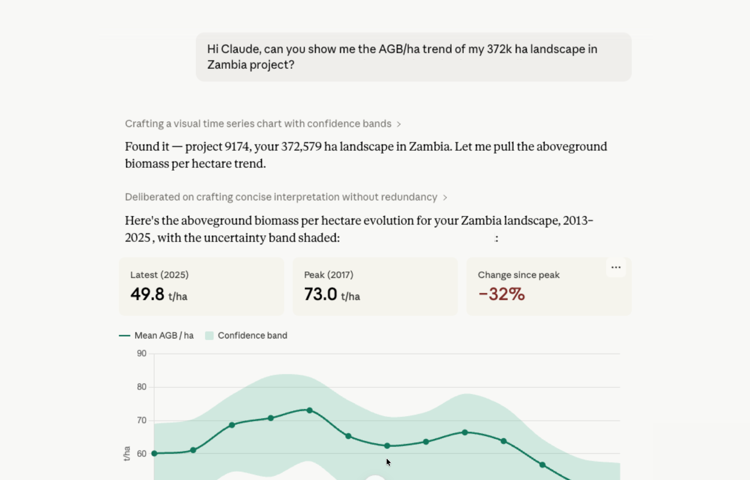
For removals reporting: We provide yearly aboveground biomass assessments using a combination of optical, radar, and LiDAR satellite data processed through proprietary deep learning models. Our dynamic baselining approach establishes historical reference levels (dating back to 2013) and tracks carbon stock changes year over year, allowing companies to distinguish genuine carbon gains from existing biomass.
For traceability: Our platform works at the farm level, supporting the most granular spatial boundaries the standard allows. We deliver site-specific data with 95% confidence intervals that can be shared with auditors and integrated into corporate reporting systems.
For permanence and ongoing monitoring: Our automated monitoring capabilities provide the continuous observation system the standard requires. Companies can demonstrate that stored carbon is being tracked over consecutive monitoring periods, with audit-ready documentation at every step.
We’re already applying this approach with a world-leading chocolate manufacturer to quantify agroforestry removals across thousands of cocoa farms in West Africa. With 80% of their emissions coming from agricultural value chains (scope 3), they needed a scalable monitoring solution aligned with the GHG Protocol Land Sector and Removals Guidance.
Our work includes stratified field plot sampling supported by historical biomass assessments, yearly farm-level biomass measurement calibrated with field data, and differentiation of carbon pools: cocoa trees versus non-cocoa shade trees, pre-existing versus newly planted. By using dynamic baselines, we can attribute carbon gains specifically to the sustainability interventions being implemented, not just measure the current state.
This kind of granular, auditor-ready data is exactly what the LSRS envisages for companies that want to report removals credibly within their scope 3 inventory.
The January 2027 effective date may seem distant, but given the data requirements involved, preparation should start now. Here’s what we recommend:
The release of the LSRS is a pivotal moment for corporate climate action. For the first time, the world’s most widely used emissions accounting framework gives companies a standardized way to account for land-based emissions and removals. The companies that build the right data infrastructure now will be best positioned to comply, report credibly, and demonstrate real impact.
If you’re navigating these new requirements and want to understand how satellite-based monitoring can support your LSRS compliance, reach out to us at hello@kanop.io.