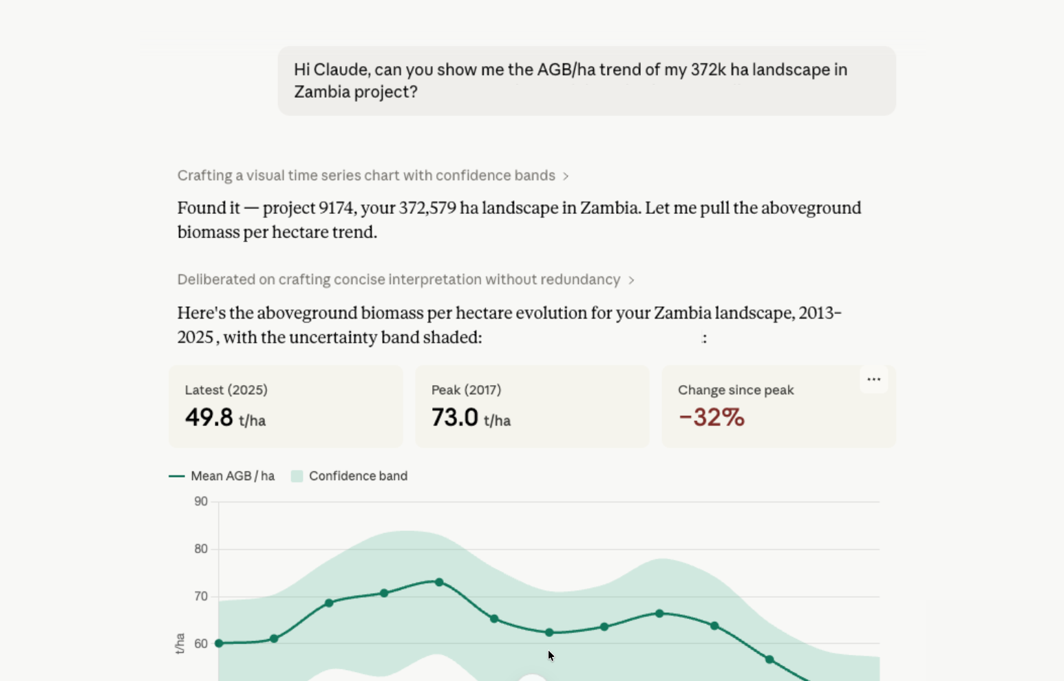
Verra’s VM0048 methodology standardizes REDD+ baselines using jurisdiction-wide deforestation risk maps, boosting the transparency and credibility of carbon credits. Kanop supports this framework with advanced GIS and remote sensing, precise baseline emissions quantification, and robust data management—all designed to help project developers confidently meet rigorous environmental standards.
Verra’s VM0048—“Reducing Emissions from Deforestation and Forest Degradation”—marks a pivotal shift in the way REDD+ project baselines are established. Rather than relying solely on project-level assessments, VM0048 leverages a jurisdictional approach to define deforestation risk and baseline emissions. At Kanop, we’re not just keeping pace with these evolving standards—we’re setting the stage for enhanced transparency, consistency, and environmental integrity in every project we support.
A New Era in REDD+: Understanding VM0048
VM0048 introduces a standardized framework that quantifies deforestation risk through jurisdiction-wide assessments. Key features include:
- Jurisdictional Baseline Assessment: Instead of local estimates, deforestation baselines are derived from broader, regional data
- Risk Mapping and Data Integration: Advanced mapping techniques identify high-risk areas by integrating historical deforestation rates and socio-economic variables.
- Transparent Emission Quantification: The methodology distinguishes between project-induced changes and deforestation that would have occurred anyway—ensuring that carbon credits are both credible and verifiable.
- Uncertainty Management: By incorporating spatial resolution requirements and uncertainty analysis, VM0048 guarantees a robust, science-backed approach to emission reductions.
This framework not only increases trust in carbon credit issuance but also sets the stage for projects to align with stringent environmental standards.
Kanop’s Integrated Approach to VM0048
While some industry voices have zeroed in on individual aspects—such as risk maps and credit volumes—Kanop’s approach is built on a comprehensive, end-to-end solution that supports every stage of VM0048 implementation. Our services include:
- Comprehensive Risk Mapping: We deploy state-of-the-art GIS and remote sensing tools to create detailed deforestation risk maps. These maps, enriched with historical deforestation data and socio-economic insights, ensure that baseline emissions are grounded in robust, jurisdiction-wide assessments.
- Baseline Emission Quantification: Leveraging methodologies from modules like VMD0055 and VMD0016, our system quantifies baseline emissions with precision. We estimate the carbon stocks before and after deforestation and integrate uncertainty analysis to provide a range of possible outcomes.
- Advanced Data Management: Our platform doesn’t simply aggregate data—it ensures rigorous quality control through cross-checking interpretations among multiple analysts, continuous calibration of our GIS tools, and secure, documented data archiving practices.
- End-to-End Support: From initial risk assessment and baseline allocation to ongoing monitoring and third-party validation support (including liaising with VVB and Verra), Kanop’s team is by your side throughout the project lifecycle.
Delivering Transparency and Trust Through Data Excellence
At the heart of our service offering is an unwavering commitment to data integrity. Our process is designed to:
- Integrate Multiple Data Sources: Whether it’s spatial risk data, forest stratification maps, or remote sensing imagery, we ensure that every piece of information contributes to a transparent, verifiable narrative.
- Document Every Step: For both environmental compliance and stakeholder assurance, we meticulously document data sources, methodologies, and quality control procedures.
- Adapt to Changing Requirements: Our systems are primed to meet evolving jurisdiction-specific definitions, and we are ready to integrate new activity data as soon as it becomes available.
Future-proofing REDD+ projects
The environmental landscape—and the regulatory frameworks that guide it—is always evolving. Recognizing this, Kanop’s platform is built to adapt. We’re already preparing for future revisions to methodologies (such as the anticipated incorporation of remote sensing in a more official capacity into VMD55), ensuring that your REDD+ projects remain compliant and ahead of the curve.