Head of Growth & Strategic Partnerships


In an era where environmental data is abundant, the real challenge lies in transforming that data into actionable insights. For stakeholders involved in Nature-based Solutions (NbS) projects—whether you're a developer, investor, verifier, or land steward—Kanop offers a powerful toolkit to support decision-making, enhance project outcomes, and increase transparency. This article explores the key ways our data can be applied throughout the NbS project lifecycle, helping you make the most of what we offer.
At Kanop, our mission is to harness AI and remote sensing to help drive finance toward nature restoration and conservation worldwide. While we often operate within the Voluntary Carbon Market (VCM), we also support organizations using alternative funding models. Take for example our collaboration with Ecosia, the tree-planting search engine. Regardless of the financing pathway, or whether you are a project developer or investor, one thing remains constant: transparent, reliable data is essential to the credibility and success of any project. Below, we explore how Kanop’s data can support your team across different project stages—and help turn your climate goals into measurable results.
De-risking a project, whether you are a developer, investor, or buyer is key. This means ensuring that the project is being developed in eligible areas (considering both environmental returns and methodological restrictions), that the baseline carbon stock is accurate and that your crediting projections are done by an independent third party with a deep understanding of the market, and more. This is where Kanop comes in. We have now developed AI Agents (see the blog post written by our CTO, Louis) that can handle these tasks for you. That means, you can now upload a shapefile with some additional project information, check back in a few hours and the information you requested will be available right in your email inbox.
Many project developers still rely heavily on ground-based data collection—a method that, while valuable for its precision, is often costly, time-consuming, and difficult to scale. To address this challenge, we are rapidly delivering high-quality, remotely-sensed data that is not only affordable, but scalable across landscapes of any size.
While remote sensing is our specialty, we don’t see it as the be all end all solution, rather, we are deep believers in a hybrid approach; calibration. This means that project developers can upload new, or pre-existing field measurements directly onto our platform, calibrating our deep learning models specifically to their ecosystem of interest, improving the accuracy of our outputs at the project level. This hybrid approach continues to empower those working on the ground while providing the highest quality scalable data for all project stakeholders to use.
A common question we receive is: How does this align with standards’ requirements? The good news is that recent methodological innovations, from a variety of standards in the market, are making it so that calibrated remote sensing outputs are becoming best-practice for biomass quantification.
One example that has seen a lot of demand from our clients is using our biomass models as a stocking index under Verra’s ARR methodology, VM0047. While NDVI is commonly used, it struggles to detect early-stage biomass growth and tends to saturate in more mature forests. In contrast, our models can identify biomass accumulation earlier and more accurately capture changes throughout the crediting period. This allows project developers to account for carbon gains that might otherwise be missed—resulting in more credits issued and stronger project integrity.
If you want support with carbon quantification for any NbS project type (REDD+ included) under any standard, please do reach out to us, we will likely be able to help out or at minimum share what we know!
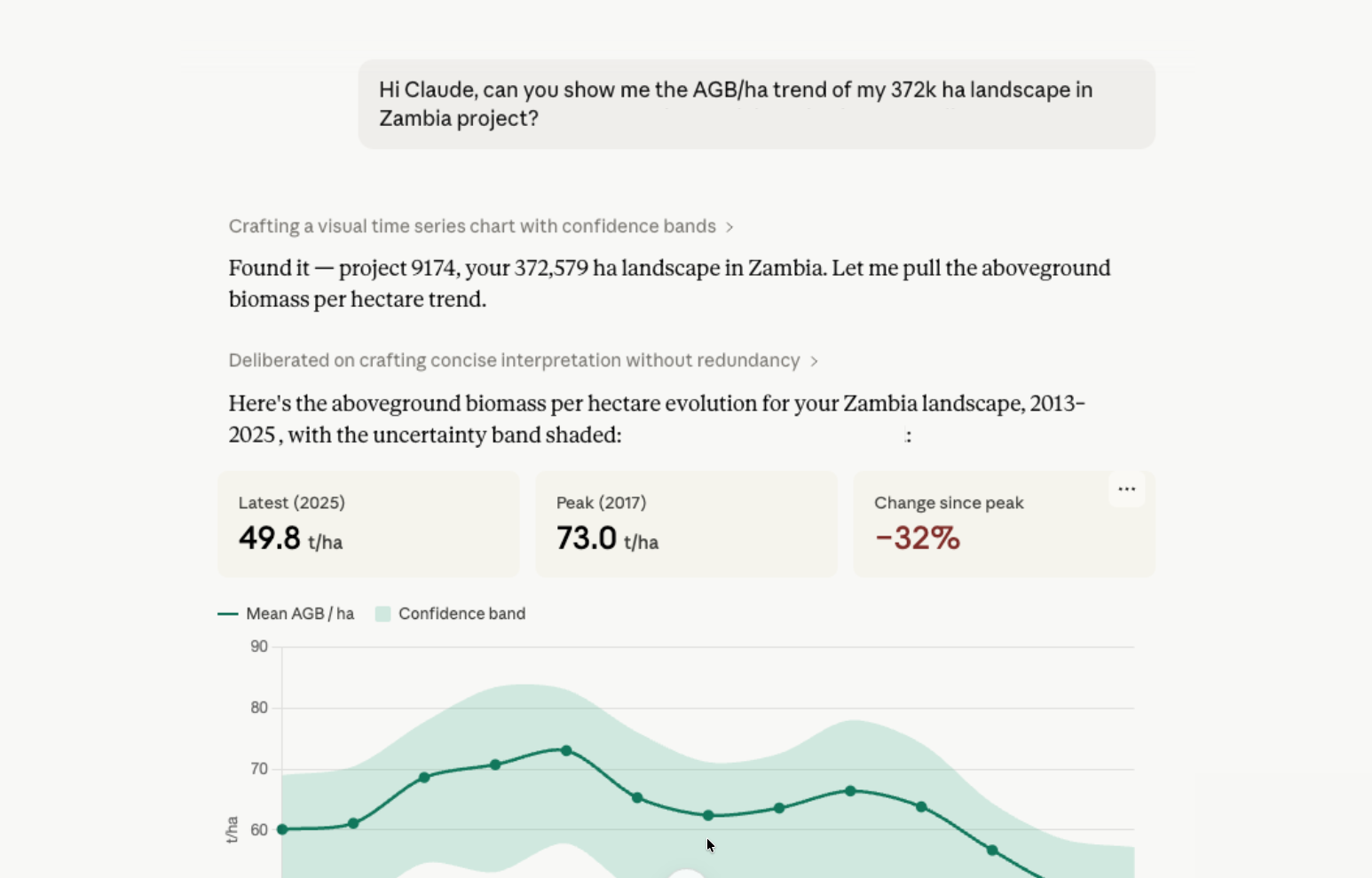
A core value of Kanop’s platform is its ability to support ongoing MRV and communicating impact. Through an interactive interface, our clients can visualize land cover changes, biomass growth, and other key indicators—making it easy to show how landscapes are evolving over time.
As natural climate solutions face increasing scrutiny, we see it as our role to help rebuild trust by making project performance visible, measurable, and verifiable. If you’re working to communicate the impact of nature restoration, our growing suite of indicators and visualization tools is here to support you—every step of the way.
If you want to see example reports, a platform demo, or our catalogue of offerings please reach out to me at coby@kanop.io and let me know what we can do to help!